|
Radiocommunications are an
integral part of information and communication technology and they are playing a
significant role in the following aspects of the ICT used in combating the
negative effects of climate change:
-
climate change monitoring;
-
actions against global
warming;
-
mitigating the local
effects of climate change.
The following is a report on the
Radiocommunication Sector
main activities relevant
to reducing the effects of
climate change with aim to be used for informing the general public on these
activities.
1. Radio
Technologies and Radiocommunication Systems Used in Monitoring Climate Change
1.1. Radio
Technologies Used in Monitoring Climate Change – Technical Background
Radio
based applications and radio systems are currently playing a very significant
role in monitoring of climate change. They provide the backbone of the Global
Observing System (GOS) created by the World Meteorological Organization (WMO).
GOS, as shown in Figure 1, is comprised of observation stations located on land,
at sea, on aircraft, and on meteorological satellites.
GOS is a composite system of complex methods, techniques and facilities for
measuring meteorological and environmental parameters. It provides observations
of the atmosphere and earth surface (including ocean surface) from all parts of
the globe and from outer space. GOS mainly relays on remote sensing equipment
placed on satellites, aircrafts, radiosondes, as well as meteorological radars
on the Earth and at sea. The system ensures that critical information is
available to every country to generate weather analyses, forecasts and warnings
on a day-to-day basis. A subset of data gathered by GOS is also used in the
Global Climate Observing System (GCOS). GCOS addresses the total climate system
including physical, chemical and biological properties, and atmospheric,
oceanic, hydrologic, cryospheric and terrestrial processes.
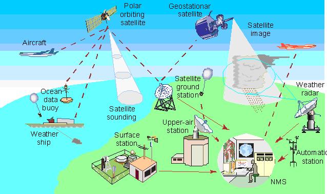
Figure 1: WMO Global Observing
System
Source:
WMO and ITU-R Handbook “Use of
Radio Spectrum for Meteorology”
Note: NMS =
National Meteorological Service
An
important aspect and additional complexity of the use of radio-based
technologies for climate control and weather forecasting is the fact that there
is no free choice of frequency bands used for environmental measurements; the
choice of the frequency band is dictated by the
physical phenomena to be observed. As shown in Figure 2 it is not possible to
use frequency bands from 75 to 100 GHz for measuring the oxygen level in
atmosphere.
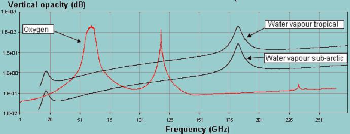
Figure 2:
Atmospheric opacity in the frequency range 1-275 GHz
Within
the framework of the climate and weather monitoring systems, radiocommunication
systems and radio applications are employed for:
-
observations
of the atmosphere and the Earth surface from all parts of the globe and from
outer space, mainly using remote active
and passive
sensors;
-
delivery of
measurement results
to international and national monitoring centres;
-
the
real-time exchange of meteorological observational data, processed products,
and related information between national meteorological and hydrological services;
-
warning the general public of dangerous events (flooding,
hurricanes, typhoons, tornadoes, thunderstorms,
the effluent from volcanoes, forest fires, and other natural and man-made disasters)2;
-
damage
assessment and planning and monitoring of disaster relief operations (see also
section 3).
Meteorological
aids, meteorological-satellite and Earth exploration-satellite
radiocommunication services play a major role in climate change monitoring and
weather forecasting. It is essential that these services have sufficient
spectrum and the frequencies allocated to these services remain free of
interference (see also Box 1).
|
Box 1:
XV World Meteorological Congress, 2007 of the World Meteorological
Organization in Resolution 3:
�
Re-affirmed the crucial importance of RF bands for
meteorological and related environmental operations and research, and
for disaster risk reduction.
�
Stressed that some RF bands are a unique natural resource for passive
sensing that deserve absolute protection.
�
Urged all Members to do their utmost at national, regional and
international levels to ensure the availability and protection of
suitable RF bands.
�
Appealed to ITU and its Administrations to ensure the absolute
protection of the passive sensing RF bands, and to give due
consideration to the WMO requirements for RF allocations and regulatory
provisions.
|
1.2
Radiocommunication Sector and Climate Change Monitoring
In this respect
the
Radiocommunication Sector
carries out the following main activities:
|
Box 2: Recognizing that the
radio frequency spectrum is a critical resource for remote sensing
employed in GOS (see Resolution 673 (WRC-07) “Radiocommunications
use for Earth observation applications”) WRC-07:
�
considered four Agenda items (with positive results) directly
related to remote sensing (including extension of frequency bands
for some active sensors);
� approved
five new Resolutions concerning new studies relevant to remote
sensing which is a vital component in the science of climate change;
� included
four items in the draft of WRC-11 Agenda on the use and further
development of remote sensing systems. |
|
Box
3:
RA-07
approved
Resolutions ITU-R
53
and
55
instructing all
ITU-R Study Groups
to carry out studies on the use of radiocommunication in disaster
prediction, detection, response, mitigation and relief. This is to
be done collaboratively within and outside ITU to avoid duplication. |
-
ITU-R Study Groups
analyze study results and proposals submitted by ITU Member States,
Radiocommunication Sector members, including the World Meteorological
Organization, international and national agencies and organizations, involved in
climate control, so as to adopt and approve relevant
ITU-R publications
(see Box 4). The results of studies corresponding to WRC Agenda items are
reported to WRCs for consideration. In accordance with WRC-07 decisions,
the main areas for studies to be reported to WRC-11 are the following:
-
use of optical links for
remote sensing;
-
development of systems for
lightning detection;
-
use of high-frequency
oceanographic radars for measurement of coastal sea surface conditions (these
radars are used for oceanographic, climatological, meteorological and disaster
response operations);
-
further development of the
meteorological-satellite systems operating near 8 GHz;
-
use of radiocommunications
for Earth observation.
|
Box
4:
ITU-R Study Groups
are very active in developing ITU-R publications relevant to the
radio systems and radio-based meteorological instruments for climate
control.
ITU-R Study Group 7
“Science Services” developed a special
RS
(Remote Sensing) series of ITU-R publications related to the use of
sensors (passive and active) for environmental activities.
SG 7
in conjunction with WMO developed the ITU/WMO Handbook On the Use of
Radio Spectrum for Meteorology. This Handbook describes modern
meteorological and Earth exploration-satellite systems, tools and
methods (see at:
http://1f8a81b9b0707b63-19211.webchannel-proxy.scarabresearch.com/publ/R-HDB-45/en).
SG 5
“Terrestrial services” (former SG 8) published Volume 4: Intelligent
Transport Systems, of the Handbook on Land Mobile (including
wireless) (see:
http://1f8a81b9b0707b63-19211.webchannel-proxy.scarabresearch.com/publ/R-HDB-49/en),
which describes how to use cars as environment monitoring equipment
(e.g., probes to measure air temperature, humidity, precipitation
– when a vehicle is near a roadside receiver these data are sent
through wireless links and used for weather forecasting and climate
control). |
-
The Radiocommunication Sector experts and BR staff participate in
international symposia, seminars, workshops and other events on climate change
(e.g. in December 2007 BR specialists participated in the workshop
on the Role of Remote Sensing in Disaster Management
organized during the
Global Forum on
Effective Use of Telecommunications / ICT for Disaster Management: Saving Lives).
Close collaboration has been established with WMO (especially with the
WMO Steering Group on Radio
Frequency Coordination (SG-RFC)),
the Space Frequency Coordination Group
(SFCG), as well as with other international and national agencies and
organizations.
|
Box 5: Studies carried out
by the ITU-R SGs provide necessary support for development and
proper operation of radiocommunication systems for climate control
and weather forecasting such as:
� meteorological and Earth
exploration-satellites that track the progress of hurricanes and
typhoons, etc.;
� space- and Earth-based
meteorological active and passive sensors that track the progress of
tornadoes and thunderstorms, the effluent from volcanoes, major
forest fires, measuring sea level (see Figure 2), many Earth’s
surface parameters (for example: soil moisture, sea surface
temperature, snow cover, rainfall, water vapour content, important
gases), etc.;
� radio-based meteorological aid
systems that collect and process weather data, without which the
current and planned accuracy of weather predictions would be
seriously compromised; and
� satellite
systems that are also used for dissemination of information
concerning different natural and man-made disasters. |
2.
Radiocommunication Systems and Concerted Action against Global Warming
2.1. Radio and
Global Warming
The
Intergovernmental Panel on Climate Change
(IPCC) concludes "most of the observed increase in globally averaged
temperatures since the mid-20th century is very likely
due to
the observed increase in
anthropogenic
greenhouse gas concentrations" which result in the
greenhouse effect.
Hundreds of millions of different radiocommunication devices utilized around the
World consume significant amounts of electricity that contribute to the
production of
the greenhouse gases.
Reduction of power consumption of radio equipment is one of the main tasks of
the Radiocommunication Sector.
2.2
Radiocommunication Sector Concerted Action against Global Warming
a) Introduction of new radio technologies
such as digital modulation for broadcasting, ultra-wideband (UWB) technology
employing extremely low power, smart antennas, etc. is also relevant to energy
saving (see Box 6). All the
ITU-R Study Groups
are concentrating their studies not only on increasing service quality and the
efficient use of the radio spectrum, but also on energy saving and reduction of
power consumption.
|
Box 6: Digital broadcasting Plan
GE06 reduces transmission power and may reduce the number of powerful
transmitters employed for TV and sound broadcasting
The Regional
Radiocommunication Conference 2006 (RRC-06), which involved 120
countries, developed a new digital broadcasting Plan GE06 that envisages
significant reduction (~7-10 dB) of transmitter power due to the use of
digital modulation. Moreover the number of transmitters (there are tens
of thousands of transmitters around the World with powers of up to
100-150 kW each) may be reduced due to the possibility of transmitting
several TV and sound programs on one channel (instead of one TV program
per channel). ITU-R BT and ITU-T H series Recommendations are used as
the technical basis for switching from analogue to digital broadcasting.
|
b) In terms of technologies for reducing
carbon emission, the use of radiocommunications might be considered as
replacing virtually the need for a physical journey. The work of ITU-R Study
Groups
4,
5 and
6,
on multimedia, is of particular importance, notably in terms of standards for
remote wireless collaboration, such as the
BO,
M,
S Series of ITU-R
Recommendations on audiovisual and multimedia systems, including
video-conferencing, which provides a means for people to collaborate at a
distance without needing to travel.
c) The Radiocommunication Sector has been
working on the spectrum requirements of intelligent transport systems (ITS)
since the early-1980s. ITS can assist in reducing carbon emissions through more
efficient traffic management, reduction of congestion, etc.
ITU-R Study Group 5
“Terrestrial services” (SG 8 before 2008) produced
Volume 4: Intelligent Transport Systems,
of the ITU-R Handbook on Land Mobile (including wireless)
in the Land Mobile Series.
d) ITU-R promotes electronic publications
(the use of a paperless approach) for submission and publication of
characteristics of frequency assignments as well as at different events (World
and Regional Radiocommunication Conferences, Radiocommunication Assemblies,
seminars, workshops, Study Group meetings, etc.) organized by the
Radiocommunication Sector.
3.
Radiocommunications in Mitigating the Local Effects of Climate Change
3.1. Technical
background
The impact of climate change and
associated disasters may dramatically increase in the future especially for some
specific areas of the World, such as low-lying coastal areas due to the rise in
sea levels. The radiocommunication services are already capable to monitor and
detect many negative effects caused by climate change including any change of
the sea level. For example the satellite remote sensing systems are permanently
measuring the ocean level and provide information concerning any change with
precision up to 2 cm. (see Figure 3). One of the governing factors, which
influences climate change and violent storms and hurricanes is increasing ocean
surface temperature. The global control of the ocean temperature is being
carried out by remote sensors from satellites (see Figure 3). Modern tools
measure the sea surface temperature with an accuracy of up to 0.2� C. These data
are used for weather forecast and prediction of natural disasters.
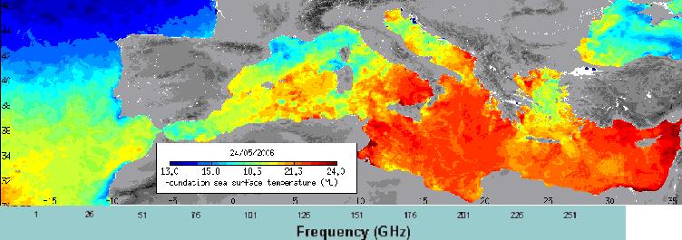
Figure 3: Mediterranean sea
surface temperature map from Envisat’s Advanced Along Track Scanning Radiometer
(AATSR) instrument
Source:
European Space Agency (http://www.esa.int/)
Disaster mitigation activities actually
eliminate or reduce the probability of disaster occurrence, or reduce the
effects of unavoidable disasters. Mitigation of negative effect of climate
change and the associated natural disasters consists of several phases such as:
-
preparedness for possible
climate change and associated natural disasters;
-
prediction of climate
change and prediction of disasters initiated by climate change. The role, which
radiocommunication systems play for climate monitoring is described in section
1. An example of a tsunami prediction system, which uses acoustic and satellite
links, is shown in Figure 4;
-
detection of natural
disasters and early warning;
-
disaster relief.
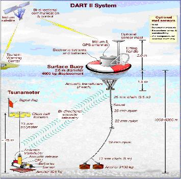
Figure 4:
Deep-ocean assessment and
report of tsunami (DART) system
Source:
National Oceanic and Atmospheric Administration – NOAA (http://www.noaa.gov)
Radiocommunication services play a very
important role at all these phases. They are especially vital in disaster relief
operations because, in many cases, when disaster strikes the “wired”
telecommunication infrastructure is significantly or completely destroyed and
only radiocommunication services can be employed for disaster relief operation
(especially radio amateurs and satellite systems).
At different phases of a disaster the
radiocommunication systems are involved in the following activities:
-
prediction, detection and
tracking of different disasters such as earthquakes, tsunamis, hurricanes,
typhoons, forest fires, oil leaks, etc. using systems of the science services
(meteorological services and Earth exploration-satellite service);
-
providing early warning information,
disseminating alert messages and advice to large sections of the public (through
systems of almost all the radiocommunication services);
-
assessment of damage and providing information for planning relief
activities (science services);
-
coordination of relief
activities by disseminating information from relief planning teams to the
concerned populations (mobile services (land, satellite, maritime, etc.),
fixed-satellite and broadcasting-satellite services).
3.2
Radiocommunication Sector activities in Mitigating the Local Effects of Climate
Change
The main activities of the
Radiocommunication Sector in mitigation of negative effects of climate change
and the associated disasters are the following:
-
WRCs allocate the necessary spectrum, paying special emphasis to
the services involved in
mitigating the
local effects of climate change and the associated natural disasters.
Conferences also consider regulatory provisions, which should facilitate the use
of spectrum and cross-border circulation of equipment intended for use in
emergency and disaster relief situations (see Box 7 and Figure 5);
|
Box 7: WRC-07 approved:
Resolution 646 (Rev.WRC-07) (an international treaty) in
emergency situations strongly recommends use of the following
regionally harmonized bands for public protection and disaster
relief:
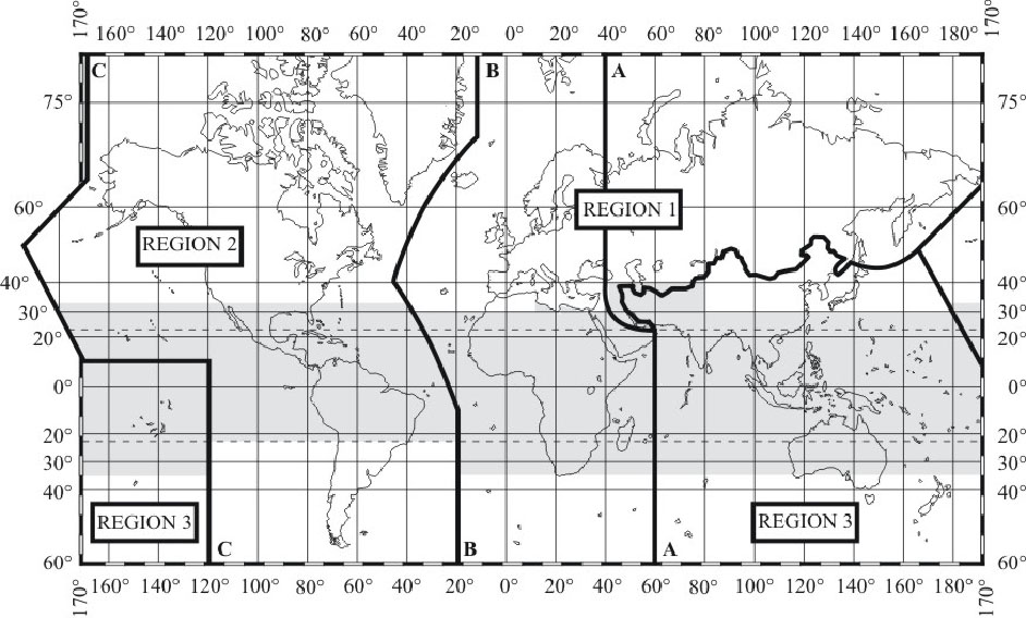
� Region 1:
380-470 MHz as the frequency range within which the band
380-385/390-395 MHz is a preferred core harmonized band for
permanent public protection activities within certain countries of
Region 1;
� Region 2:
746-806 MHz, 806-869 MHz, 4 940-4 990 MHz;
� Region 3:
406.1-430 MHz, 440-470 MHz, 806-824/851-869 MHz, 4 940-4 990 MHz and
5 850-5 925 MHz
ITU
Regions
Resolution 647 (WRC-07)
advocated the development of spectrum management guidelines for use
of radiocommunications in emergency and disaster relief as well as
the identification and maintenance of available frequencies for use
in the very early stages of humanitarian assistance intervention in
the aftermath of disaster. ITU is developing a database for
frequency management in disaster situations. Such a database in
conjunction with the modern software defined radio will allow quick
delivery of radio equipment, which will operate in accordance with
the national regulations. |
-
Radiocommunication
Assemblies request the ITU-R to study aspects of radiocommunications relevant to
disaster mitigation and relief operations.
RA-07 approved
Resolutions ITU-R
53 and
55 that
identifies areas that
ITU-R Study Groups
could address in their studies/activities and develop guidelines related to the
management of radiocommunication systems in disaster prediction, detection,
mitigation and relief. This is to be done collaboratively within and outside ITU
to avoid duplication.
-
All
ITU-R Study Groups
develop and regularly update ITU-R Recommendations, Reports, Handbooks providing
the technical basis for development and use of a majority of radiocommunication
services (amateur, broadcasting, satellite-broadcasting, Earth
exploration-satellite, meteorological and meteorological-satellite, fixed and
fixed-satellite, mobile and mobile-satellite, radiodetermination services, etc.)
for early warning of
the public of impending disasters, for planning and relief operations, and
in emergency situations
(see Box 8).
Box 8:
Maritime mobile Access and Retrieval System (MARS)
This system has been
developed by the International Telecommunication Union (see
http://1f8a81b9b0707b63-19211.webchannel-proxy.scarabresearch.com/ITU-R/terrestrial/mars/)
with the purpose of providing the Maritime Community, in particular
those entities that are involved in search and rescue activities,
with the most up-to-date data registered in the ITU master Ship
station database. Updated weekly and available on a 24-hour per
day/7-day per week basis, this system contains characteristics of
over 400 000 ship stations as well as the addresses and contact
information of Accounting Authorities (AAICs) and Notifying
Administrations. |
-
Much of the work
undertaken within the
ITU-R Study Group 5
“Terrestrial services” (former SG 8) has been in support of Radio Regulatory
texts and procedures addressing distress and safety communications and many
relevant provisions, derived from this work, now exist in Articles of the RR.
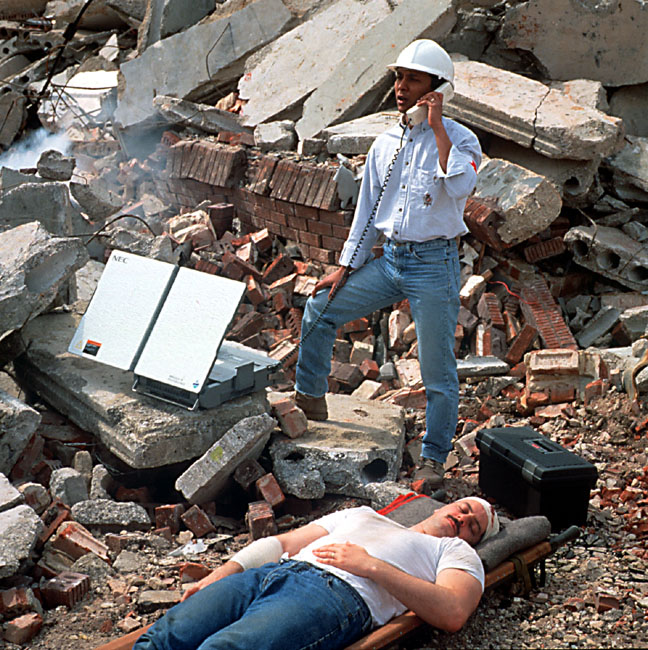
Figure 5:
Example of satellite radiotelephony used in case of a natural disaster
Photo credits: INMARSAT
The Radiocommunication Sector cooperates
with other ITU Sectors and contributes to ITU activities related to the use of
ICT in combating the negative effects of climate change.
For additional information please
see:
ITU
News magazine (January-February 2008) -
ICT and climate change: The challenges, solutions, and the role of ITU.
ITU Radio Regulations No. 1.182: active sensor: A measuring
instrument in the earth exploration-satellite service or in the
space research service by means of which information is obtained by
transmission and reception of radio waves.
ITU Radio Regulations No. 1.183: passive sensor: A measuring
instrument in the earth exploration-satellite service or in the
space research service by means of which information is obtained by
reception of radio waves of natural origin.
|


